


GS-200G Handheld Laser Scanning System


Product Parameters
| System Specifications | |||
| Point Cloud Accuracy | Relative Accuracy ≤1cm Absolute Accuracy ≤5cm |
Power Supply Range | 12-20V |
| Overall Dimensions | 16.5*12*32.4cm | Device Weight | 1.0kg |
| Operating Temperature | -20ºC-55ºC | System Power Consumption | <25W |
| Storage Capacity | 128GB SD Card | Mounting Platforms | Handheld / Backpack / Airborne / Vehicle-mounted |
| POS Performance Specifications | |||
| Model | gSpin 210 | Roll Accuracy | 0.015° |
| Data Update Rate | 200Hz | Heading Accuracy | 0.040° |
| Positioning Accuracy | Horizontal 0.02m, Vertical 0.03m | Pitch Accuracy | 0.015° |
| GNSS Signal Types | GPS L1/L2; GLONASS L1/L2 (GLO); Galileo E1/E5b (GAL); BDS B1/B3/B2a (Supports BeiDou-only mode) | ||
| Laser Performance Specifications | |||
| Range | 40m@10%, 70m@80% | Ranging Accuracy | ≤2cm@10m, ≤3cm@0.2m |
| Horizontal Field of View (FOV) | 360° | Vertical Field of View (FOV) | -7°-52° |
| Point Rate | 200,000 pts/s (Single Echo) | Scanning Mode | Non-Repeat Scanning |
| Camera Specifications | |||
| Resolution | 2*20MP | Field of View (FOV) | Horizontal 200°, Vertical 200° |
| Mapping | |||
| Mapping Methods | SLAM: RTK-SLAM; PPK-SLAM | ||
Applicable Scenarios


FAQ
1. Who are we?
We are an integrated factory and trading company, with our own factory production and 65 CNC machining centers. Our customers are all over the world, and we have expanded many categories according to their needs.
2. How can we guarantee quality?
We have a special quality inspection department before we leave the factory, and of course it is very important that we will strictly control the quality of each production process throughout the whole production process, so our products can reach a 99.5% pass rate.
3. What can you buy from us?
Professional drones, unmanned vehicles and other devices with high quality.
4. Why should you buy from us not from other suppliers?
We have 19 years of production, R&D and sales experience, and we have a professional after sales team to support you.
5. What services can we provide?
Accepted Delivery Terms: FOB, CIF, EXW, FCA, DDP;
Accepted Payment Currency: USD, EUR, CNY;
Accepted Payment Type: T/T, L/C, D/P, D/A, Credit Card.
-

EV-Peak U1+ Lipo Battery Charger 1200W 25A Inte...
-

New Professional-Grade Flight Controller Apo22m...
-
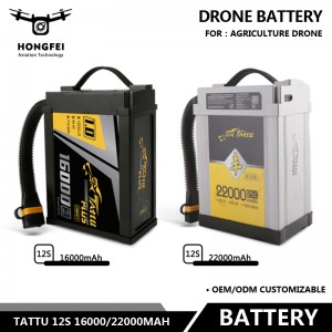
Tattu 12S 16000/22000mAh Agricultural Uav Lipo ...
-
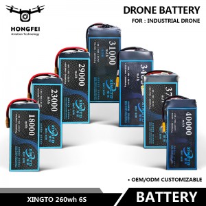
Xingto 260wh 6s Intelligent Batteries for Drones
-

GS-920X Base Station Free Long Range Drone LiDA...
-
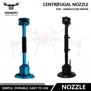
New Nozzle 12s 14s Centrifugal Nozzles for a Wi...