In response to the four major difficulties of UAV aerial surveys previously proposed, the industry is also actively taking some feasible measures to improve them.
1) Sub-area aerial surveys + simultaneous operations in multiple formations
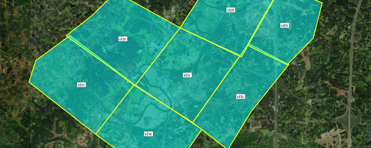
In conducting large-area aerial testing, the operation area can be divided into multiple regularly shaped areas by combining elements such as terrain and geomorphology, climate, transportation, and drone performance, and dispatching multiple drone formations to conduct sub-area aerial testing at the same time, which will shorten the operation cycle, reduce the impact of climate change on data collection, and decrease the cost of time.
2) Increased flight speeds + Expanded shooting area in a single shot
Increasing the flight speed of the drone and shortening the shooting interval at the same time can increase the effective time of collecting data and improve the operational efficiency. And we can utilize the way of increasing the size of the sensor or multi-camera stitching technology to increase the area of the single shot photo, in order to improve the total area of the drone single aerial photography.
Of course, these also put forward higher requirements for drone performance, drone load capacity and camera development.
3) Combination of image-control-free + manual deployment of image-control points
Due to the long time consuming aerial survey of large area by drones, it is possible to combine the image control-free function of drones with the manual laying of image control points, and manually lay image control points in advance in key positions such as areas with inconspicuous features, and then carry out the measurement of the image control points at the same time as aerial surveying by drones, which can effectively save the time of laying image control points and image control measurements under the circumstance of guaranteeing the accuracy of the data, and increase the efficiency of the operation.
In addition, the drone aerial survey is a professional and multidisciplinary cross-fertilization field, want to deepen the application and development, need to strengthen the information exchange between the drone industry and the surveying and mapping industry, and constantly absorb talents to participate in the practical application of large-area aerial surveys, to provide more professional advice and rich experience.
Drone large-area aerial survey application is a long exploration process, although at present it is still facing many problems, but this also shows that the drone in large-area aerial survey application has huge market potential and plenty of space for development.
Looking forward to the new technology, new products as soon as possible, to bring a new development in the field of drone aerial survey.
Post time: Aug-15-2023